
New Delhi: The Deep Depression over the south-east and adjoining south-west Bay of Bengal has intensified into Cyclonic Storm Akvan, the India Meteorological Department (IMD) said on Monday. At 5:30 pm IST on November 16 it lay over the central parts of the south and adjoining west-central Bay of Bengal, about 610 km east of Chennai.
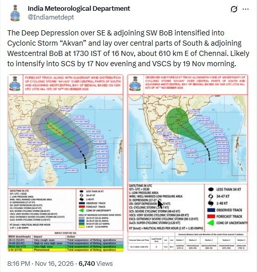
Screenshot: India Meteorological Department on X

IMD said the system is likely to intensify into a Severe Cyclonic Storm by the evening of November 17 and into a Very Severe Cyclonic Storm by the morning of November 19.
Landfall forecast
In a follow-up post, IMD said the storm is likely to cross the Andhra Pradesh and Yanam coasts between Nellore and Tuni around noon of November 20 as a Very Severe Cyclonic Storm, with wind speeds of 120–130 kmph gusting to 145 kmph.
IMD’s forecast track map, based on 1730 IST of November 16, shows the system moving north-west towards the Andhra Pradesh coast, with the centre at 12.2°N, 85.7°E at that time, 610 km east of Chennai, 630 km north-east of Trincomalee, 660 km south-east of Machilipatnam, 670 km south-south-east of Visakhapatnam and 790 km south of Gopalpur.
Impact over the sea
IMD’s chart advises a total suspension of fishing operations over the affected sea areas, with rough to phenomenal seas depending on wind speed: very rough seas for winds of 52–61 kmph, high to very high seas for 62–91 kmph, very high seas for 92–117 kmph and phenomenal seas for 118 kmph or more.